
by Alan Rudd
I have been accused of having too many boats. Anybody that loves the water and understands that water transport has been a vital part of human existence, should naturally be attracted to boats and boating. It is after all deep in the human psyche to want to cross the waters and see what is on the other shore, and for most of human history bridges have been few and far between.
There is no such thing as too many boats!
On June 20, 2022, my son Adam (36 years old USAF veteran) and I checked waterdata.usgs.gov and noted that Lake Whitney flood gates were being opened every night allowing a 4000 cubic feet per second (cfs) gush of water to proceed toward the coast and downstream users. Even though most rivers in Texas have been at extremely low flow rates all spring and summer, this water management strategy kept the Brazos River at a nice steady flow from Waco to the Gulf of Mexico, and perfect for canoe travel.
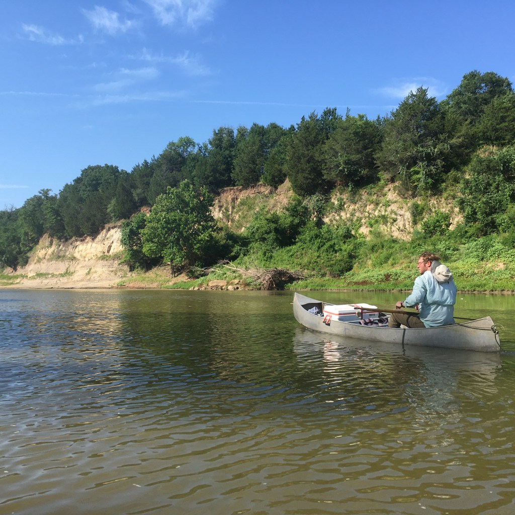
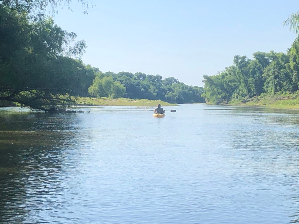
We had scouted a reach of river that borders Milam and Robertson County from Google Earth photographs and by examining the access points at several highway crossings. This was a stretch of the Brazos I had never been on and pulling under the FM 979 bridge west of Calvert was the beginning of a very special day. Angie was the shuttle driver. She took command of the truck after we unloaded my 1982 Grumman canoe, and an Ocean Kayak. We estimated that we could cover the 16 miles of river by 3 pm and that was the default rendezvous time at the next highway bridge on FM 485 near Hearne.
The only person we saw the entire day was a young man in a small motor boat at the launch point under the 979 bridge. We talked as three boaters should, about the river conditions, his cat-fishing success, and marveled that we had common friends down in Somerville. This polite young man named Austin said he is alone most of the year fishing this stretch of river that is blocked upstream and downstream by large rock structures that prevent most motorized boating. I was somewhat unnerved by the fact that he was surprised that we thought we could make it all the way to FM 485 Angie had already spun wheels in the gravel to go shopping in Bryan so there really was nothing left to do but head downriver.
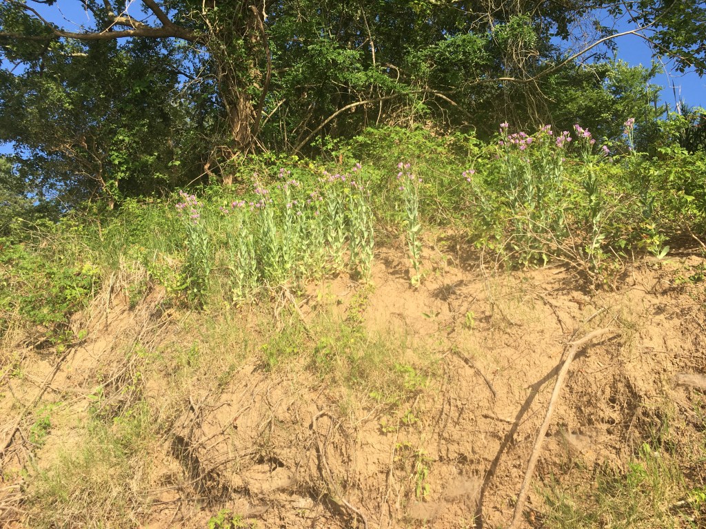
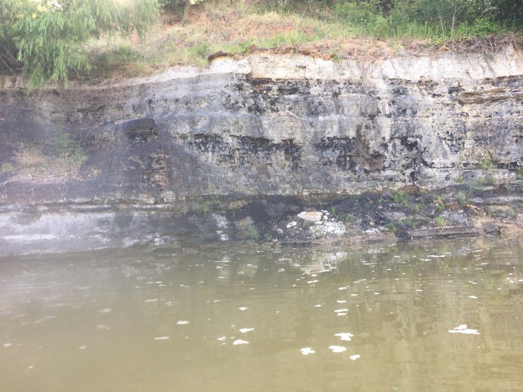
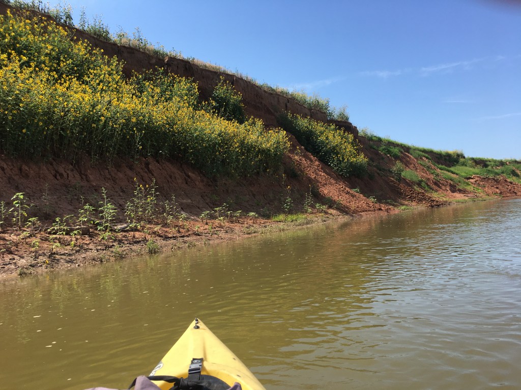
We paddled in the shade of very large cottonwood trees, Texas ash, and black willows that form a high green curtain on both banks of the river. It would be 100 degrees later in the day, but the first three hours were delightful. At a rocky riffle less than a mile from the bridge two bald eagles launched from their observation posts and crisscrossed the river in front of us. I observed blue bells flowering on a clay embankment on the Milam County side. Spotted gar and alligator gar were surfacing alongside the boats most of the day, and you could distinguish them by their different skin color patterns in the moderately clear water. We passed through one location where the river cut through deep clay banks that sandwiched a 15-20-foot-thick vein of lignite. Spring water flowed from above the lignite seam and dripped into the river with and audible trickle. On this 16 river-mile reach we observed no less than seven spring-water inflow locations. The dripping and flowing spots alike felt to be about 70 degrees F to the touch of a hand when the river water was in the high 80s. One spring I estimated was running 6-8 gallons per minute and dropped at an angle where you could paddle under it and catch water in a canteen. I just filled my hat and then enjoyed an impromptu cold shower on river right. I carry large sponges to bail the canoe out when this indulgence strikes me.
We did see cattle tracks, beaver sign, feral hog rooting, and wallow sites, but did not see a single human footprint the whole way. We found and picked up exactly two pieces of litter (a Gatorade bottle and a soda can). There were three tractor tires that had obviously washed down decades ago from farm operations just out of sight through the trees, but it was a joy to paddle a track where the trappings of modern society were not in plain view.
The large sweeping bends of the Brazos River produce huge sand bars on the inside of each curve. One on river right (the Milam County side) appeared to be 80-100 acres in size and was dotted with mussel or clam shells of many species. What a great camping spot to pitch a tent in the soft sand. Invariably these sand bars are across from a steep soil bank into which the river is carving and eroding away the deep alluvial deposits of red sand and clay. I searched with my eyes for evidence of bones protruding from these crumbling soil banks. Mastodon skeletons have been discovered by boaters in just such a search pattern. I seem to remember one excavation in the 1980s by Dr Gentry Steele, a Texas A&M professor that was alerted to a fossil find by river paddlers.
If I’d had a talented birder along (especially one with perfect pitch who knew birds by sound) it would have been a good time to listen and learn. I know the sound of painted bunting males as they are abundant around my home is Burleson County. Buntings were singing in the jungle along the river though on this day I never caught sight of one on either shore. Much other birdsong emanated from the trees and tangled vines, but I could not interpret the notes nor the silence between the notes.
Blue herons love to hunt in the shallow riffles on the Brazos. They were present in cadres of 8-12 individuals and were never happy to see us approaching. I thought it was odd that we saw only one white heron all day. Cliff swallows were fledging young from nest holes that were burrowed into the crumbling red soil of one high bank on the Robertson County side (river left). I have seen them nesting on rock overhangs on the Rio Grande, but this display showed how they could have a nesting colony on the lower Brazos before the advent of concrete bridges that serve them so well these days.
The end of the river run brought us to a massive rock structure about ¾ mile upstream of the FM 485 bridge. This sandstone formation blocks the path of the Brazos and eons of the wear and tear of flowing water have not been able to dramatically alter its presence.
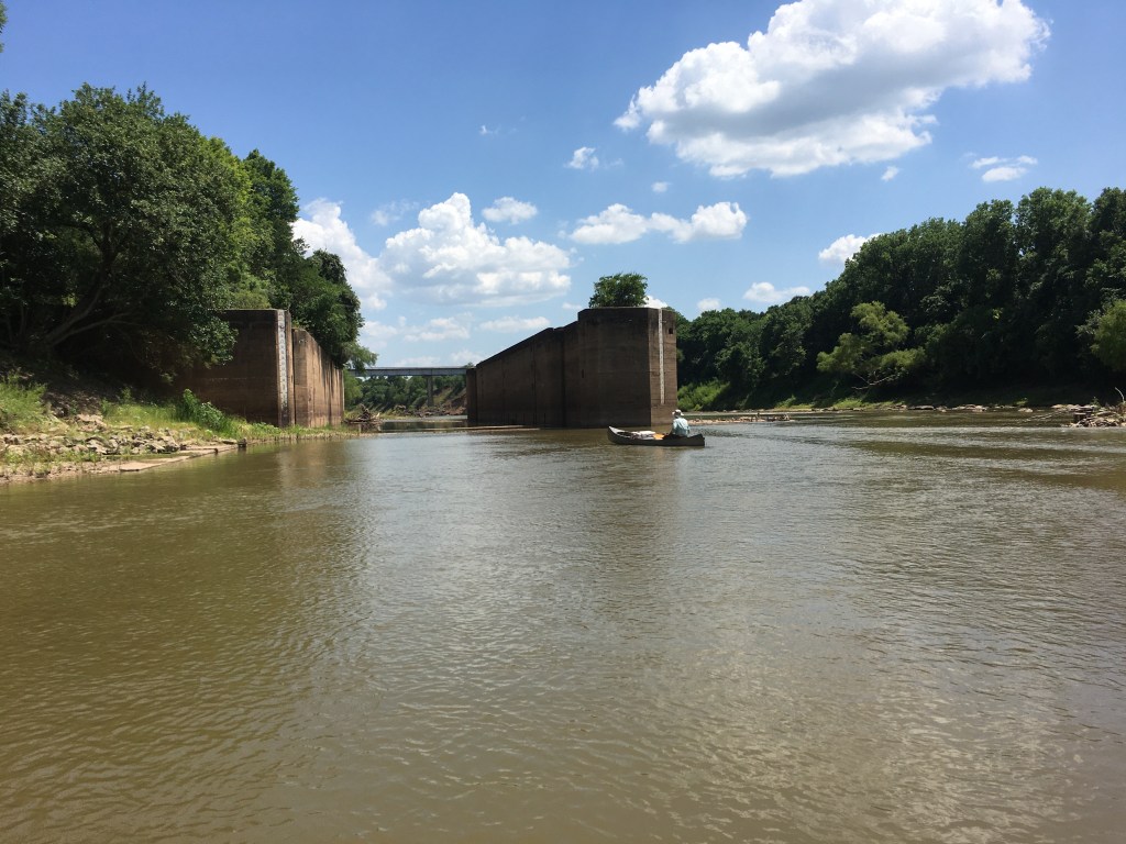
In the late 1800s US government officials toyed with the idea that the Brazos River should be fitted with locks and dams such that steamboats could be run from the coast to Waco, Texas. Paddle-wheel steamboats of earlier decades could power upstream from Freeport all the way to Washington on the Brazos. A rock formation known as Hidalgo Falls blocked any meaningful traffic further upstream. The lock and dam proposal was shelved in the 1890s because railroads were doing a capable job of moving freight about the country. The idea was revisited, however, and circa 1905 construction was started on several of the proposed eight locks and dams. It seems a flood wrecked much of the work within a few months and another attempt after WWI saw Lock #1 (Hidalgo Falls), Lock #3 (Port Sullivan now FM 485), and Lock #8 at Waco, all earnestly under construction.
Lock # 8 at Waco in fact was completed and stood proudly until a massive flood in 1923 bypassed this man-made obstruction as the river rerouted itself. This same flood also apparently clobbered #3 and #1 as it lumbered to the Gulf. When I spoke with Eric Neubauer about this story, he mentioned having seen the lock and dam on a Google Earth image still present in the middle of a farmer’s field near Waco. At any rate the Feds abandoned the project 99 years ago and the remains of three structures are all that is left of that early attempt at freight hauling on the Brazos.
So, back to that sandstone structure that I approached with trepidation. The 800 cfs of water flow was chaotic and looked dangerous to me. A good pathway through the rocks was not clear. As commander of this expedition, I stood on a mid-river boulder that resembled a giant biscuit. Without hesitating, Adam paddled past me through a maze of other giant biscuits (if I were allowed to name this formation today it would be Pillsbury Falls).
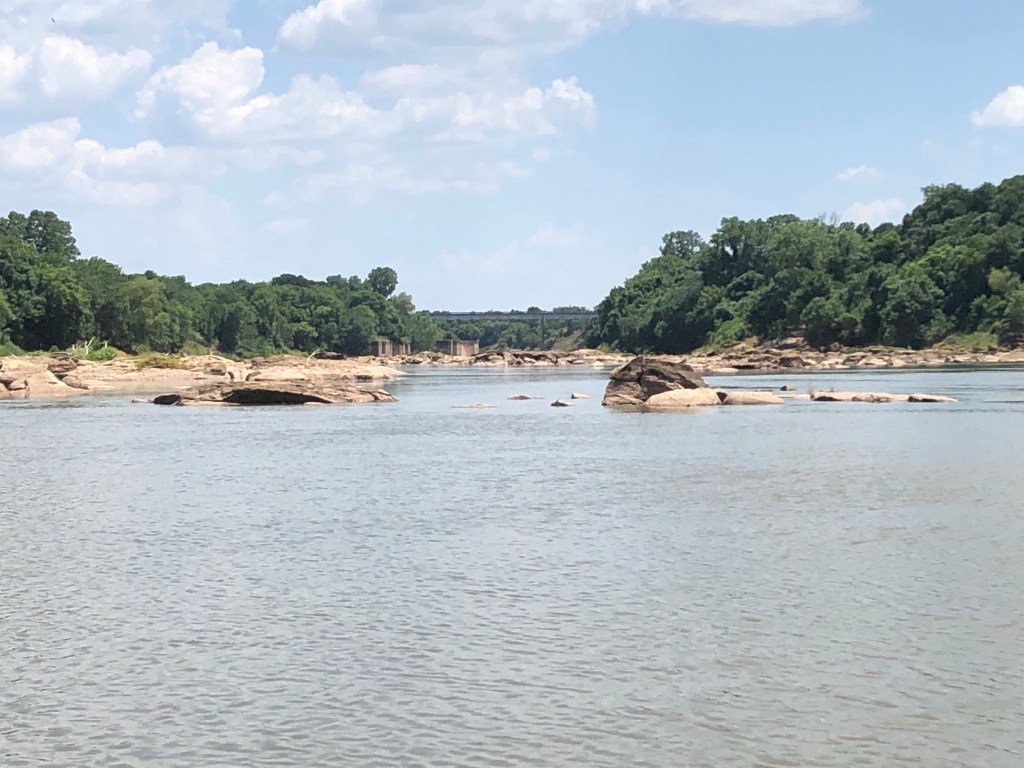
Working my way through in the kayak I saw Adam had cleared the formation in the Grumman using several daring maneuvers. He was a combat airlift pilot so supplying him with a canoe built by a company that made WWII fighters just emboldened the pair to run the rapids pell-mell. The entire formation was perhaps 275 yards in length with multiple passages. It would be quite a nasty spot to traverse at 1800 cfs.
Directly below Pillsbury Falls was what remains of Lock #3 that was abandoned almost a century ago. This massive concrete structure dwarfs all human traffic on the river and clearly will stand for thousands of years. Watching the water flow through its 23-foot-high walls and across its perfectly flat concrete bottom made me wonder about the crew of engineers and laborers that strove to build this structure. Some of their equipment is a tangle of steel and wood downstream and near the current highway bridge. I don’t want to have to go through those upstream boulders at high water, but it would be fun to go shooting through that giant concrete lock one day.
After pulling the boats out under FM 485 bridge, we took a quick shampoo/shower with buckets of well water from the back of the truck. Changing into dry, clean clothes we were off to Coats Grocery in beautiful downtown Gause for ice cream. And the problem about “too many boats?” You either have enough to do the job or you don’t. No Problem.
